

The Bhu-mandala has features that identify it as a model of the solar system. Scholars Giorgio de Santillana and Hertha von Dechend conducted an intensive study of myths and traditions and concluded that the so-called Loka or "Earth" in ancient times originally represented the plane of the ecliptic (the orbit of the sun) and not the Earth (a planet) on which we stand. The details given in the Vedas show that his cosmology was much more developed.
The ecliptic model, and the Bhu-mandala disk correspond to the solar system. The solar system is nearly aligned with the Sun, moon, and five other planets; Mercury through Saturn, all orbit almost in the plane of the ecliptic. So, Bhumandala does refer to something flat, but it's not Earth. If we compare Bhu-mandala's rings with the orbits of Mercury, Venus, Mars, Jupiter, and Saturn, we find several close parallels that give weight to the hypothesis that Bhu-mandala was deliberately designed as a map of the solar system.

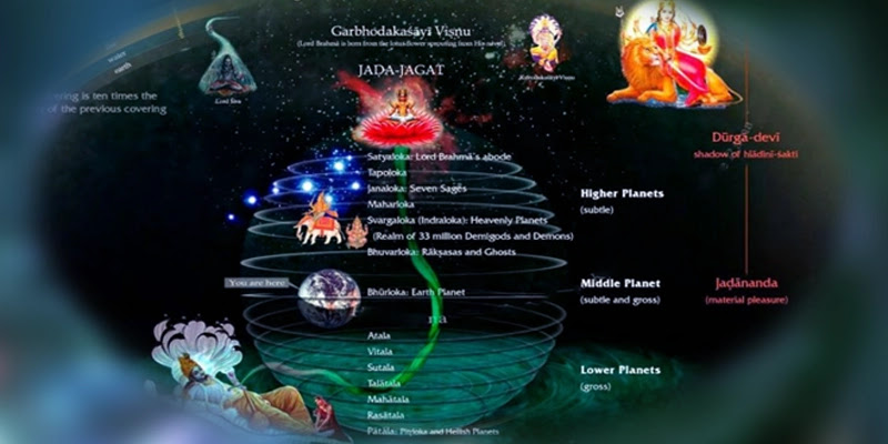
In the Vedas, the universe is described as an egg surrounded by a layer of elemental matter which is the boundary between the mundane space and the infinite spiritual world.
The area inside the shell is called Brahmanda or “Brahma egg”. It contains a disk or plane of the earth called the Bhu-mandala , which divides it into an upper, middle and subterranean part filled with water. The Bhu-mandala is divided into a series of geographical features, which are traditionally called Dvipa , or Islands, Varsha or Regions and oceans. The circular island of Jambudvipa , located in the center of Bhu-mandala ) with nine varsha subdivisions .
Its subdivision is known as Bharata-varsha , i.e. India / Bharata. In the center of Jambudvipa stands the cone-shaped Mount Sumeru, which symbolizes the axis of the world and is flanked by the city of Brahma, the creator of the universe.

Bhu-mandala is a stereographic projection of the world's land area between the equator and the Bharata-varsha mountain arc , corresponding to the size of the Indian territory.
This shows that night is diametrically opposite to the point of day. Likewise, the sun sets at the point opposite to where it rises.

In the Middle Ages, a modern astronomical instrument called the astrolabe was used to compare the Bhu-mandala. In the astrolabe , the off-center circle represents the sun's orbit i.e. the ecliptic. The Earth is represented in a stereographic projection, called the ' mater '. The ecliptic circle and important stars are represented on another plate, called the ' rete '. The orbits of different planets may also be represented by different plates, and these will appear to be projected onto the Earth's plates when one looks down at the instrument.
The Vedas also present the orbits of the sun, moon, planets and important stars on a series of planes parallel to the Bhu-mandala .
According to other Puranas, Bhu-mandala is a map of the middle or heavenly realms of the gods. The general understanding of Bharata-arsha covers the entire globe, while the other eight varshas refer to the middle realms that exist beyond Earth.
But the simplest explanation for the middle/heavenly realm i.e. Jambudvipa is that Bhu-mandala, is also meant to represent the realm of the gods.
Literature is full of parallel world stories. For example, the Mahabharata tells the story of how the daughter of Naga Ulupi kidnapped Arjuna while he was bathing in the Ganges River. Ulupi pulled Arjuna down not to the bottom of the river, as we might expect, but to the kingdom of Nagas (celestial beings like snakes) that existed in another dimension of nature.
The mystical journey explains how the world of the gods is connected to the world of humans. In particular, it explains how Jambudvipa as the heavenly realm of the gods is connected with Jambudvipa as Earth or part of the Earth. Thus, Jambudvipa's dual model makes sense in terms of the Puranic understanding of siddhis .
Modern science currently estimates the Earth to be a sphere 8,000 miles in diameter rotating at 1,000 mph, while orbiting the sun at 67,000 mph, simultaneously orbiting the galaxy at greater speeds. The Himalayas appear to have an average elevation of nearly 4 miles and stretch for about 1,400 miles.
In the Vedas, the universe is described as an egg surrounded by a layer of elemental matter which is the boundary between the mundane space and the infinite spiritual world.
The area inside the shell is called Brahmanda or “Brahma egg”. It contains a disk or plane of the earth called the Bhu-mandala , which divides it into an upper, middle and subterranean part filled with water. The Bhu-mandala is divided into a series of geographical features, which are traditionally called Dvipa , or Islands, Varsha or Regions and oceans. The circular island of Jambudvipa , located in the center of Bhu-mandala ) with nine varsha subdivisions .
Its subdivision is known as Bharata-varsha , i.e. India / Bharata. In the center of Jambudvipa stands the cone-shaped Mount Sumeru, which symbolizes the axis of the world and is flanked by the city of Brahma, the creator of the universe.
Bhu-mandala is a stereographic projection of the world's land area between the equator and the Bharata-varsha mountain arc , corresponding to the size of the Indian territory.
This shows that night is diametrically opposite to the point of day. Likewise, the sun sets at the point opposite to where it rises.
In the Middle Ages, a modern astronomical instrument called the astrolabe was used to compare the Bhu-mandala. In the astrolabe , the off-center circle represents the sun's orbit i.e. the ecliptic. The Earth is represented in a stereographic projection, called the ' mater '. The ecliptic circle and important stars are represented on another plate, called the ' rete '. The orbits of different planets may also be represented by different plates, and these will appear to be projected onto the Earth's plates when one looks down at the instrument.
The Vedas also present the orbits of the sun, moon, planets and important stars on a series of planes parallel to the Bhu-mandala .
Bhu-mandala as Map of the Heavenly Realm of the Gods
According to other Puranas, Bhu-mandala is a map of the middle or heavenly realms of the gods. The general understanding of Bharata-arsha covers the entire globe, while the other eight varshas refer to the middle realms that exist beyond Earth.
But the simplest explanation for the middle/heavenly realm i.e. Jambudvipa is that Bhu-mandala, is also meant to represent the realm of the gods.
Literature is full of parallel world stories. For example, the Mahabharata tells the story of how the daughter of Naga Ulupi kidnapped Arjuna while he was bathing in the Ganges River. Ulupi pulled Arjuna down not to the bottom of the river, as we might expect, but to the kingdom of Nagas (celestial beings like snakes) that existed in another dimension of nature.
The mystical journey explains how the world of the gods is connected to the world of humans. In particular, it explains how Jambudvipa as the heavenly realm of the gods is connected with Jambudvipa as Earth or part of the Earth. Thus, Jambudvipa's dual model makes sense in terms of the Puranic understanding of siddhis .
Jambūdvīpa and Bhārata-varṣa
Modern science currently estimates the Earth to be a sphere 8,000 miles in diameter rotating at 1,000 mph, while orbiting the sun at 67,000 mph, simultaneously orbiting the galaxy at greater speeds. The Himalayas appear to have an average elevation of nearly 4 miles and stretch for about 1,400 miles.
The sun and the moon, though said to be very different in size, and very far apart in distance, appear exactly the same size to us, and appear to rise and set on the horizon. The Purāṇa describes the Himalayas as having a maximum length of 640,000 miles and an altitude of up to 16,000 miles.
In an attempt to describe the arrangement of the universe, Sr ukadeva, in the Bhāgavata Purāṇa, said this:
"My dear king, there is no limit to the expansion of the material energy of the Supreme Lord. This world is only the transformation of the three material qualities, but no one is can explain it perfectly, even in a lifetime during the Brahma world"
And in the Brahmaṇḍa Purāṇa, Srī Suta explains,
"Man mentions the magnitude of the universe by guessing alone. One cannot arrive just by guessing, to things which cannot be contemplated. What is beyond nature is called Achintya (the inconceivable)". The
contents of this chapter discuss how the term Bhārata -varṣa has been applied simultaneously to the Indian subcontinent, to the entire Eurasian landmass, and to include the entire Earth as we know it.
It describes how the world we live in goes through the cosmic cycle of time, in which floods, Ice ages and Golden ages affect the shape and size of the world, and the consciousness of past and future civilizations. This chapter also maps out the mysterious frontier regions that connect the human realm with the other realms, known as Jambūdvīpa and Sumeru.
The description of Bhārata as India is found in every Purāṇa, and is called Puṇya Bhūm i, Land of the Seven Rivers, land of the seven mountains of kula-parvata , land of Nava-Khaṇḍa or Nava-dvīpa , which are in the eight directions described by the astronomers Parasara and Varāhamhira .
Division of Bharata-varṣa into Nine Khaṇḍas
The description of Bhārata as India is found in every Purāṇa, and is called Puṇya Bhūm i, Land of the Seven Rivers, land of the seven mountains of kula-parvata , land of Nava-Khaṇḍa or Nava-dvīpa , which are in the eight directions described by the astronomers Parasara and Varāhamhira .
According to this arrangement, Panchala was the main district of the central division, Magadha to the east, Kalinga to the southeast, Avanta to the south, Anarta to the southwest, Sindhu-Sauvira to the west, Harahaura to the north - west , Madra to the north, and Kauninda to the northeast. The list of Varāhamihira abstracts is in the same order as the Markaṇḍeya Purāṇa.
By comparing detailed lists of works such as Siddhanta-Siromani, with works by Brahmanda, Markandeya, Vishnu, Vayu, and Matsya Purāṇas ; it was found that, despite various repetitions and renamings, as well as many different sources, all lists refer to essentially the same thing. Although most Purāṇas mention the Nine Divisions and give their names, only Brahmanda, Markandeya and Skanda mention the names of the districts in each of the Nine Divisions. They follow the same order in all; namely, Indradvīpa, Kaśeru, Tāmradvīpa, Gabhastiman, Nāga, Saumya, Gāndharva, Varuṇa and Kumārikā . No description is given to identify these names, but they do mention Indradvīpa in the east, Varuna in the west, andKumarika in the middle.
Unfortunately to date, these undefined divisions have made them hard to find. However, by carefully studying the Purāṇ literature, the key to identifying this Nava-dvīpa Bhārata is finally revealed.
In the Vishnu Purāṇa (by Srila Visvanatha Cakravarti Thakura)
"Listen to the nine divisions of Bhārata-varṣa. They are Indradvipa, Kaśeru, Tāmravarna, Gabhastimant, Nagadvipa, Saumya, Gāndharva, Vāruṇa, and the ninth [Navadvipa] near the sea in the middle- the middle of the other eight islands [“sagara saṁvṛita” means located near the sea*]. It stretches 1,000 yojanas from north to south. On the east, Kirata lives and on the west is yavana".
To the east of the island are the inhabitants of Kamarupa (Assam). People with HIV, Kalinga and Magadha are all residents of the south. (VP 2.3.6-9)
Acarya Srila Visvanatha translates sagara-saṁvṛta as 'near the sea' and NOT 'separated by the sea', as the latter is often used in Sanskrit in many other Puranas which duplicate this verse. Here too the ninth division 'navadvipa' is unmistakably identified with India which stretches 1,000 yojanas from the ocean to the Himalayas. Therefore, in this interpretation, Bharata-varsa must be equal to the entire mainland of Eurasia, of which the Indian peninsula is the ninth part.
Siddhānta-śiromaṇi (Golādhyāya, Bhuvana-kośa, Chapter 3 verse 41-42)
“In the Bharata-varṣa, there are nine khaas. They are known as (1) Aindra, (2) Kaśeru, (3) Tāmraparṇa, (4) Gabhastimat, (5) Kumārikā, (6) Naga, (7) Saumya, (8) Vāruṇa and (9) Gāndharva. In Kumārikā alone we find the division of men into castes, in the remainder of the khaa we find all the tribes of Antyajas or the excluded male tribes. In this region [Bhāratavarṣa] there are also seven Kriachalas (mountains). Mahendra, Sukti, Malaya, Rishika, Pāriyātra, Sahya and Vindhya hills.”
This list places the previously unnamed dvīpa Kumārikā in the center. More importantly, these verses describe division as Khaṇḍa (literally 'division' or 'section') and are associated with, or separated by, the famous seven mountains of Bhārata.
This is a completely different picture, that the “islands” are part of the land south of the Himalayas and surrounded by seas, the most important and central of which is Kumārikā-Khaṇḍa.
In order to stop quarrels between different people, Mahārāja Priyavrata marked boundaries on rivers and on the edges of mountains and forests so that no one violated the property of others. (SB 5.1.40)
In order to stop quarrels between different people, Mahārāja Priyavrata marked boundaries on rivers and on the edges of mountains and forests so that no one violated the property of others. (SB 5.1.40)
Vāyu Purāṇa (45,78-82)
There are nine islands attached to Bhārata-varṣa, separated by oceans. One cannot go to one island from another. They are Indradvīpa, Kaśeru, Tāmraparna, Gabhastiman, Nāgadvīpa, Saumya, Gandharva, Varuna and Bharata himself ninth.
The Bhārata-varṣa is a thousand yojanas from south to north, extending from Kanyākumār in the south to Gangotri in the north. From east to west is 9,000 yojanas, Mleccha is always near and beyond the borders of this varṣa . To the east is Kirata and to the west is Yavana .

Agni Purāṇa (Chapter 118 v1-5):
“1. The state (located) north of the ocean and south of the Himadri (Himalayas) is known as Bhāratavarṣa which stretches to nine thousand (yojanas) 2-4. This is the land of religious rituals. This gives the accomplishment of action in obtaining redemption. Mahendra, Malaya, Sahya, Suktimat, Hemaparvata, Vindhya and Pariyatra are the seven main mountains here. Indradvīpa, Kaśeru, Tāmravarṇa, Gabhastimān, Nāgadvīpa, Saumya, Gāndharva, Vāruṇa and Bhārata are the nine provinces here surrounded by the ocean. 5. The continent stretches up to a thousand yojanas from north to south. There are nine divisions of Bhārata located around the central part with Kirata in the east and Yavana in the west. ”
Mārkaṇḍeya Purāṇa (54: 5-6 & Chapter 55)
“Surrounded by the ocean are the nine divisions of Bhārata-varṣa – all inaccessible to one another. They are Indradvīpa, Kaśeru, Tāmraparṇa, Gabhastimān, Nagadvīpa, Saumya, Gāndharva, and Vāruṇa.”
This measurement repeated in many Puranas shows the yojana value to be approximately 1.5 miles. This identifies Bharata with the Eurasian continent.
Agni Purāṇa (Chapter 118 v1-5):
“1. The state (located) north of the ocean and south of the Himadri (Himalayas) is known as Bhāratavarṣa which stretches to nine thousand (yojanas) 2-4. This is the land of religious rituals. This gives the accomplishment of action in obtaining redemption. Mahendra, Malaya, Sahya, Suktimat, Hemaparvata, Vindhya and Pariyatra are the seven main mountains here. Indradvīpa, Kaśeru, Tāmravarṇa, Gabhastimān, Nāgadvīpa, Saumya, Gāndharva, Vāruṇa and Bhārata are the nine provinces here surrounded by the ocean. 5. The continent stretches up to a thousand yojanas from north to south. There are nine divisions of Bhārata located around the central part with Kirata in the east and Yavana in the west. ”
Mārkaṇḍeya Purāṇa (54: 5-6 & Chapter 55)
“Surrounded by the ocean are the nine divisions of Bhārata-varṣa – all inaccessible to one another. They are Indradvīpa, Kaśeru, Tāmraparṇa, Gabhastimān, Nagadvīpa, Saumya, Gāndharva, and Vāruṇa.”
This chapter describes all the kingdoms in the nine divisions of Bhārata, and the following summary clearly shows that the nine so-called “dvīpas” of Bhārata are actually the nine divisions of the Indian subcontinent: (1) the central part, including Sārasvatā, Panchala Hills and Aravali (Pāriyātra) , (2) head (east), including Māgadha, Lohitya and Kosala, (3) right leg (southeast), including Kalinga, Andhra and Vidarbha, (4) right side (south) including Maharashtra, Karnataka, Kāver river, Malaya Mts, Siṁhala and Laṅkā. (5) the right hind leg (southwest) includes the Pahlava, Indus and Saurashtra rivers. (6) the tail (west) includes Tarakshuras (Iran), Asta-giri (Afghanistan) and Panchanada (Punjab). (7) Left hind leg (northwest), including Asvaka-Kambhojas, Bāhlikas (Bactria) and Kandahar (8) left-hand side (north) including Kailash, Himālayas, Kashmir, Takṣaśilā (Taxila), Huns (Tibet) and Rasalaya (Lhasa). (9) the northeastern foothills, including, the mountain villages of Kiratas, Yavanas and Pauravas, the Koshi River (Nepal) and Vana-rastra (Assam). These are all located on the map below.

Skanda Purāṇa ( Maheśvara Khaṇḍa, Book 2, Chapter 39)
While the Mārkaṇḍeya Purāṇa accurately places the nine khanda of Bhārata in the world, the greatest Purana of all is the one that gives the origins of these nine names. The Skanda Purāṇa gives the account of how this division got their name, and how Kumarika-devi donated her share to her brothers, Indradvīpa, Kaśeru, Tāmravarna, Babhasimān, Nagadvīpa, Saumya, Gāndarva, Vāruṇa. Next he divides each 'Khaṇḍa' or 'Dvīpa' into eight more parts, and states the number of villages in each of them. This resulted in a list of 72 regions that lie in South Asia, or Greater India called “Bhārata-Khaṇḍa”.
“Śrī Nārada said: There is a man named bha whose name, O son of Pṛtha, will be associated with many heretical concepts and views in Kali Yuga [Jainism]. They will contribute to the delusions of the whole world. Bharata is his son. ataśṛṅga is his son. Eight sons and a daughter were born to him. They are ndradvīpa, Kaśeru, Tāmradvīpa, Gabhastiman, Naga, Saumya, Gāndharva and Varuṇa. The girl's name was Kumārikā.
He [King ataśṛṅga] divided this Bhārata continent into nine regions. Eight of them he gave to his [eight] sons and the ninth to Kumār.
The Kūrma-vibhāga, or nine parts Bhāratavarṣa – in the form of a turtle, from the 55th (sometimes 58th) chapter of the Mārkaṇḍeya Purāṇa.
Skanda Purāṇa ( Maheśvara Khaṇḍa, Book 2, Chapter 39)
While the Mārkaṇḍeya Purāṇa accurately places the nine khanda of Bhārata in the world, the greatest Purana of all is the one that gives the origins of these nine names. The Skanda Purāṇa gives the account of how this division got their name, and how Kumarika-devi donated her share to her brothers, Indradvīpa, Kaśeru, Tāmravarna, Babhasimān, Nagadvīpa, Saumya, Gāndarva, Vāruṇa. Next he divides each 'Khaṇḍa' or 'Dvīpa' into eight more parts, and states the number of villages in each of them. This resulted in a list of 72 regions that lie in South Asia, or Greater India called “Bhārata-Khaṇḍa”.
“Śrī Nārada said: There is a man named bha whose name, O son of Pṛtha, will be associated with many heretical concepts and views in Kali Yuga [Jainism]. They will contribute to the delusions of the whole world. Bharata is his son. ataśṛṅga is his son. Eight sons and a daughter were born to him. They are ndradvīpa, Kaśeru, Tāmradvīpa, Gabhastiman, Naga, Saumya, Gāndharva and Varuṇa. The girl's name was Kumārikā.
He [King ataśṛṅga] divided this Bhārata continent into nine regions. Eight of them he gave to his [eight] sons and the ninth to Kumār.
"I will describe the various regions made beautiful by the mountains. Hear from me the mountains and the subcontinents named after their sons."
Mahendra, Malaya, Sahya, uktimān, kṣaparvata, Vindhya and Pāriyātra - these seven are the main mountains.
Indradvīpa is said to be outside Mahendra. The Kumārika subcontinent is said to be located on the lower slopes of Pāriyātra. Each of these regions extends to a thousand (Yojana).
Indradvīpa is said to be outside Mahendra. The Kumārika subcontinent is said to be located on the lower slopes of Pāriyātra. Each of these regions extends to a thousand (Yojana).
Having divided the kingdom between his sons and daughter Kumār, the ataga king went to the mountain in the north and performed penance. Kumār the extraordinary virgin of great wealth lived in Stambhatīrtha.
With the wealth that comes from his subcontinent, he performs rituals of giving in charity and austere penance. After some time, nine sons full of vigor, strength, and vigor were born to each of the eight brothers. They gathered, approached Kumār and spoke (thus):
“O great woman, you are the goddess of our family. Be happy with us. Divide these eight sub-continents into seventy-two territories by yourself."

These are the seven mountains which determine the location of the Bhārata-varsa in every Purana: the Pariyatra, Riksha, Vindhya, Suktimat, Mahendra, Malaya, and Sahya mountains. Their location can be confirmed by the rivers that still flow from them today, as many retain their ancient names.
Those who read the full 39th chapter will find a very similar story to Parvati 's incarnation as a tapasvi, a teenager ( Kumāri-devi) who performs penance for Lord Siva at the sacred confluence of the three oceans at Cape Kanya-Kumāri .
Although each of the nine Khaṇḍas is said to be 1,000 yojanas in size, we can understand by comparing the distance of the Kaliyuga from Gangotri to Kanya-kumari , that the entire region of Asia and Europe is being discussed here. These are the ninth dvīpa in South Asia which are surrounded by oceans.
When we read the Skanda Purana's description that half the kingdoms are by the sea, it is understandable how grammatical errors can make them appear to be separated by the ocean. It is a great fortune that this Purana clarifies the exact location of Kumarika and Indradvīpa, finally solving the mystery of the nine islands.
Often in Purānaic literature the Indian sub-continent is considered the only civilized (or important) region of Bhārata, and is usually divided into 5 sections; four petals and a center, while the rest of Eurasia is said to be inhabited by Mlecchas. Generally they are called Yavana, Tukhara, Kirata and Cina, who are said to live beyond the borders of Bhārata-varṣa.
The geography of the ancient Vedas and Puranas is dominated by the description of the land between the Sarasvati River and the Ganges, where civilization was repeatedly initiated by the incarnations of Manu and the great sage born of Brahma's mind. Initially the land of the Aryans or cultured peoples was only limited to this area, but in all directions the names of tribes and provinces were known. In time, the entire subcontinent was civilized and ruled by King Bhārata, and in eons ago these kings took tribute from all over the Earth. The names of distant islands, continents and peoples are recorded in old stories.

The actual list of thirteen islands, including eight from the Bhāgavata Purāṇa, is most likely a variation of the list in the Vāyu Purāṇa, plus those mentioned in the Mahābhārata and Ramayana.
Often in Purānaic literature the Indian sub-continent is considered the only civilized (or important) region of Bhārata, and is usually divided into 5 sections; four petals and a center, while the rest of Eurasia is said to be inhabited by Mlecchas. Generally they are called Yavana, Tukhara, Kirata and Cina, who are said to live beyond the borders of Bhārata-varṣa.
The geography of the ancient Vedas and Puranas is dominated by the description of the land between the Sarasvati River and the Ganges, where civilization was repeatedly initiated by the incarnations of Manu and the great sage born of Brahma's mind. Initially the land of the Aryans or cultured peoples was only limited to this area, but in all directions the names of tribes and provinces were known. In time, the entire subcontinent was civilized and ruled by King Bhārata, and in eons ago these kings took tribute from all over the Earth. The names of distant islands, continents and peoples are recorded in old stories.
Old map of Jambudvipa showing the varsa and branches of the Ganges River (translated into English)
The actual list of thirteen islands, including eight from the Bhāgavata Purāṇa, is most likely a variation of the list in the Vāyu Purāṇa, plus those mentioned in the Mahābhārata and Ramayana.
The thirteen islands can also be used as references for 12 or 14 mountains that became islands in the ocean for fear of Mahendra (Indra).
The Vāyu describes at least nine islands located in the saltwater ocean surrounding the Bhāratavarṣa peninsula. In Vāyu these islands are described in some detail and can therefore be identified with some degree of certainty.
This list of islands (except Laṅkā, Siṁhala and Yava) is not mentioned in the other Purāṇas, most of which have lists of nine khaṇḍas starting with Indradvīpa.

Purāṇic World Map-Bhāratavarṣa and Upadvīpa-Karma-kṣetra Islands and Continent
Many of the islands described here lie in the Indian Ocean, with references to those in the Pacific Ocean as well, while some that are inaccessible to humans are heavenly islands such as the heavenly varṣa Jambūdvīpa. Although much scriptural, historical, geological and geographical evidence has been used to identify these islands and continents as described in the third chapter of the book Purāṇic Geography .
| NAMA DVĪPA | MODERN NAME |
BHAGAVATA P. |
|
| Svarṇaprastha | Java, Sumatra, Philippines (Suvarṇadvīpa) |
| Candraśukla | The heavenly island west of Uttarakuru |
| Ramaṇaka | Fiji (remote tropical island of Kaliya) |
| vartana | Antartika (avartana = kembali dari) |
| Mandara-hariṇa | Madagascar (Historic Harina) |
| Pāñcajanya | Borneo (conch shaped with white mountains) |
| Siṅhala | Sri Lanka (Sinhala Land) |
| Laṅkā | Laccadive Ridge & Maldives (Treta yuga) |
MAHABHARATA |
|
| Dragon | Sumatra &/or Java (Rabbit Ears) |
| Kaśyapa or Karna | Peninsular Malaysia (Rabbit Ears) |
| Susa | Eurasia & Afrika (Jack-Rabbit) |
| peep | North & South America (Fig Tree) |
| dvīpas . vegetation | Indonesia, Australia (Fruit & Vegetation) |
RAMAYANA |
|
| Yava | Java/Sumatra |
| Yava-dvīpas | Indonesia / Philippines |
| Mount Varaha | Mount Meru, Africa ("western Arabian Sea") |
VARAHA P. |
|
| Siṅhala | Ceylon (Sri Lanka) |
| Kataha | Kedah (Peninsula Malaysia) |
| Candradvīpa | White Isles of the Moon (west of Uttarakuru) |
| Bhadrakara | Western Golden Islands (outside Candradvīpa) |
| Suryadvīpa | Sun Gold Island (north of Uttarakuru) |
VAYU P. |
|
| Gunung Vidyutvān | East Africa Rift Range |
| Bahrain Islands | Papua, Pacific Islands & America |
| But | Australia |
| Yama | Sumatra (Suvarna or Yavadvīpa) |
| Nagadeśa | Australia (Land of snakes) |
| Malay | Java (Yava Islands) |
| Kancanapada Gn. | In Java (Mount Semeru) |
| aṅkha | Borneo |
| Kumuda | Thailand & Cambodia (Land of the Kumuda Lotus) |
| Varaha | Africa (Aryan Nile) |
| Laṅkā | Laccadive Ocean Ridge – Maladewa |
HISTORICAL |
|
| Sukhadhara | Socotra |
| Maharatna-dvīpa | Madagaskar (Harina) |
| Bali-dvīpa | Bali or Balāhaka |
| Radha-dip | Rhodes (Greek Is. Rhodos) |
| Astra-laya | Australia |
| Kuṣṇa-dvipas | Andaman & Nicobar Islands. |
| Barhan-dip | Sulawesi, Timor, Solomon Is, Fiji, Tahiti, dll. dll. |
| Barhan-dip | New Zealand, Nan Madol, Hawaii, Easter, etc. |
Alam Achintya (Unimaginable)
Geometry states that If we take a bull and tie it to a post in 2D space, it will form a finite circle. If the bull is strapped in 3D space, he enters the "limited sphere", if the bull is tied in 4D space, he moves in the finite hypersphere. This is the fourth dimension of Sadaputa's 5th Canto mathematics. If the jiva goes in a straight line in a hypershpere, it will eventually return to where it started. This is the condition we observe on Earth. If we fly or sail in a straight line, we end up returning to our point of origin. This is the Bhārata-varṣa lotus petal which is described many times in the Puranas as "Achintya".
Surya-siddhanta, which is accepted as an ancient Sanskrit text much older than the Greek or Babylonian, makes a very interesting calculation by taking this model of Jambudvipa, and its four main cities (one on Earth, and the other three in the heavenly varshas) and transposing them at the equator of the mathematical globe we. Even if this makes no sense at all, try to follow the process as described in the text:
Surya-siddhanta, Chapter 12, Slokas 52-53
Likewise, those on the same path (samasṇtrastha) regard each other as (located) below. For example, the inhabitants of Bhādrāśwa or Ketumāla or the inhabitants of Laṅkā and the inhabitants of the perfect place lie on the same line. Due to the spherical shape of the earth (vartula), people everywhere consider themselves to be the topmost. But since the globe lies in the ether, then what are the ups and downs?
In one chapter, the flat description of the four main varshas of Jambudvipa somehow becomes a description of a globe with these varshas at the equator. No wonder this process is beyond mundane logic!

Here we have the standard model of Jambudvipa in the center of Bhu-mandala, surrounded by the ocean. On the coast, in the cardinal directions, are placed the four cities of the gods, Siddhapuri, Yamakoti, Lanka and Romaka. We are then asked to place these non-Earth cities on the equator of our Earth 'globe' at 90 degrees to each other, starting with Lanka, which represents Earth's latitude and longitude of 0° North & 75,7885° East. This process is 'achintya' has no logic!
Surya-siddhanta tells us to change the position of that Jambudvipa , with Meru at its centre, to the northern hemisphere of the math sphere. The North Pole now represents Meru, the Axis Mundi, and the equator represents the circular edge of Jambudvipa, and lying on it is Lanka Ravana, just south of Meru/North Pole on the Vedic Meridian past the eternal Saptapuri Ujjain. Prime Meridian of Vedic Astronomy.
Today Siddhapuri (presumably the northernmost town of Jambudvipa in Uttarakuru) is located in the Pacific Ocean almost directly south of Roswell, New Mexico. Sadaputa explains it like this in the Vedic Astronomy book .
Refer to the diagram above or the illustration 'Mapping Longitude and Latitude of Bharata-varsa' below. Does all this make sense? No, it is inconceivable, " Achintya " but this field mathematics used by modern astronomy and Surya-siddhanta actually explains what we see in the sky.

The map above attempts to illustrate the synthesis of the Purāṇic and Jyotiśa descriptions of the Earth. Yojana has different quantities according to the research point of view. In the Sūrya-siddhānta, there are several measurement quantities, including Solar, Sidereal and Civic (14.1-2).
If one makes a horoscope, the arc-shaped Bharata becomes a mathematical sphere “1600 yojanas in diameter” (eg: NP.54.81) placed in the center of the celestial sphere. From a geographical perspective, the Puranas give the distance from the North Pole to Antarctica to be 9,000 yojanas, and India's length is one-ninth of the “one thousand yojanas from Kanyakumari to Gangotri” (eg: VāP.42.80) . If we compare Meru's size with the Himavan Mountain Barrier which is 80,000 years old, then the southern salt ocean bow containing Earth's continents is on average 36,000 yojanas wide because “Jambūdvīpa is circular like a sun disc” and the mountain boundaries “enter” the sea”.

